 TANTO Blog
Geographic Information Systems and geomatics open source software projects for DESKTOP. See also other list "Open source GeoSpatial Web Applications".
Quantum GIS (QGIS) is a user friendly Open Source Geographic Information System (GIS) licensed under the GNU General Public License. QGIS is an official project of the Open Source Geospatial Foundation (OSGeo). It runs on Linux, Unix, Mac OSX, and Windows and supports numerous vector, raster, and database formats and functionalities.
uDig is an open source (LGPL) desktop application framework, built with Eclipse Rich Client (RCP) technology.
uDig can be used as a stand-alone application.
uDig can be extended with RCP “plug-ins”.
uDig can be used as a plug-in in an existing RCP application.
PostGIS adds support for geographic objects to the PostgreSQL object-relational database. In effect, PostGIS "spatially enables" the PostgreSQL server, allowing it to be used as a backend spatial database for geographic information systems (GIS), much like ESRI's SDE or Oracle's Spatial extension. PostGIS follows the OpenGIS "Simple Features Specification for SQL" and has been certified as compliant with the "Types and Functions" profile.
GRASS GIS (Geographic Resources Analysis Support System) is an open source, free software (FOSS) Geographical Information System (GIS) with raster, topological vector, image processing, and visualization functionality.
gdal is a translator library for raster geospatial data formats that is released under an X/MIT style Open Source license by the Open Source Geospatial Foundation. As a library, it presents a single abstract data model to the calling application for all supported formats. It also comes with a variety of useful commandline utilities for data translation and processing
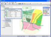
gvSIG is a desktop geographic information system (GIS), designed for capturing, storing, handling, analyzing and deploying any kind of referenced geographic information in order to solve complex management and planning problems.
SAGA GIS is a GIS software with the purpose to give (geo-)scientists an effective but easily learnable platform for the implementation of geoscientific methods.
sqlite extension enabling spatial data processing for GIS
a complete Spatial DBMS in a nutshell
The OGR Simple Features Library is a C++ open source library (and commandline tools) providing read (and sometimes write) access to a variety of vector file formats including ESRI Shapefiles, S-57, SDTS, PostGIS, Oracle Spatial, and Mapinfo mid/mif and TAB formats.
OGR is a part of the GDAL library.
OpenJUMP is an open source Geographic Information System (GIS) written in the Java programming language. It is developed and maintained by a group of volunteers from around the globe. OpenJUMP started as JUMP GIS designed by Vivid Solutions.
Gaia is a platform designed for advanced geospatial network and SDI needs. Based on the CarbonTools PRO open-geospatial development toolkit, this viewer can access an array of geospatial sources distributed with Open Geospatial Consortium (OGC) standards.
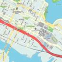
Mapnik is a Free Toolkit for developing mapping applications. Above all Mapnik is about making beautiful maps. It is easily extensible and suitable for both desktop and web development.